Monforte de Lemos to Rodeiro.
The past two days have been wonderful. The weather continues to be fine, sometimes hazy, but the sun always shining, and the scenery continues to delight. The walking has been strenuous at times, but the sights more than make up for it.
Thankfully, the dogs have improved, or I should say, the control of them has. The big, scary ones have all been either on a chain, or behind a high fence. I left Monforte de Lemos in fog, but as the day progressed the sun burnt it off and it was a lovely day.


Chantada, my next stop after Monforte de Lemos, was a beautiful town. The buildings were interesting and the people caring and helpful. My guide notes said it had arcaded streets, and on chatting with the hotel receptionist I learnt that these "arcades" are called soportalis and exist solely so that the home owners can get inside their homes without getting even wetter. He assured me that from October to May it barely stops raining, but, fortunately for me, this is a dry autumn. We also had a chat about my observations that there seems to be more affluence in this part of Galicia. He thought it might be because the rivers have provided work, and made work easier. The rivers provide water for the vines (and these days the electricity) and in the past the water provided the power to work grain mills etc.


Getting to Chantada was hard work, as I had a couple of big ascents and descents. I had left the River Sil, and this was the day I crossed the Rio Miño, but have now left that far behind too. Approaching the Rio Miño I had to follow a very steep path downhill. It was very rocky, and the way the rocks were arranged so carefully made me think that I was probably walking on an ancient road. Parts of the path hadn't seen the sun all day and so the rocks glistened with moisture, reminding me to take care. The path was so steep that it zig-zagged it's way down the hill, and once over the bridge, the road I chose to follow (less steep) zig-zagged up the hill! Despite the incredible steepness, every available piece of arable land was in use, primarily with vines, but some vegie patches too. The vineyards are terraced, and as I plodded up the hill in the late afternoon, wherever I looked, I could see people out, tending the vines.


I was a bit weary arriving in Chantada, and after dinner went straight off to bed, leaving my exploring till the following morning. I also did a bit of unplanned exploration, as my notes and the signs didn't quite match, but a second breakfast, and a closer look at the map got me sorted, until lunch time! The day began with a slow, steady ascent, which escalated to a much steeper one some nine kilometres later. This was so that the Alto de Faro could be climbed, which is, I am informed, the geographical centre of Galicia. The views from the top were stunning. The Ermita de Nosa Señora do Monte do Faro is near the top of this climb, in the middle of a clear field. I sat there, alone, amidst the blooming crocus, with magnificent views wherever I cared to look and ate my lunch. I could hear no sounds, except for a bee buzzing amongst the crocus.


When it came time to push on I had my first real "don't know" moment on this journey. I couldn't find any yellow arrows, only a mojón pointing down the hill. I went that way briefly, it felt wrong and so I climbed back up to check I hadn't missed anything. Still no joy, and so climbed the few metres to the top of the Alto, and again, no joy! I consulted Google maps and decided that I would forgo the Camino and make my own way to Rodeiro where I planned to spend the night. The route it took me was on tiny little tracks, and with no uphills to speak of. At one point, in the distance I could hear a dog/s barking, and was a little fearful. As I approached the small hamlet, the dogs let loose, and were loose, but fortunately their masters were sitting on a wall having a late afternoon natter. I stood still and waited for things to calm down, had a chat to the two men and a woman, and headed off to Rodeiro, reaching my destination about a half hour later.


Santiago is close. I will be glad to reach my destination and stop, but sad too that I will have no more walking to do. That is always the way!

Thankfully, the dogs have improved, or I should say, the control of them has. The big, scary ones have all been either on a chain, or behind a high fence. I left Monforte de Lemos in fog, but as the day progressed the sun burnt it off and it was a lovely day.

I wasn't paying attention as I left Monforte de Lemos, and just missed injuring myself on this abnormally low slung overhang!

Looking through the fog.
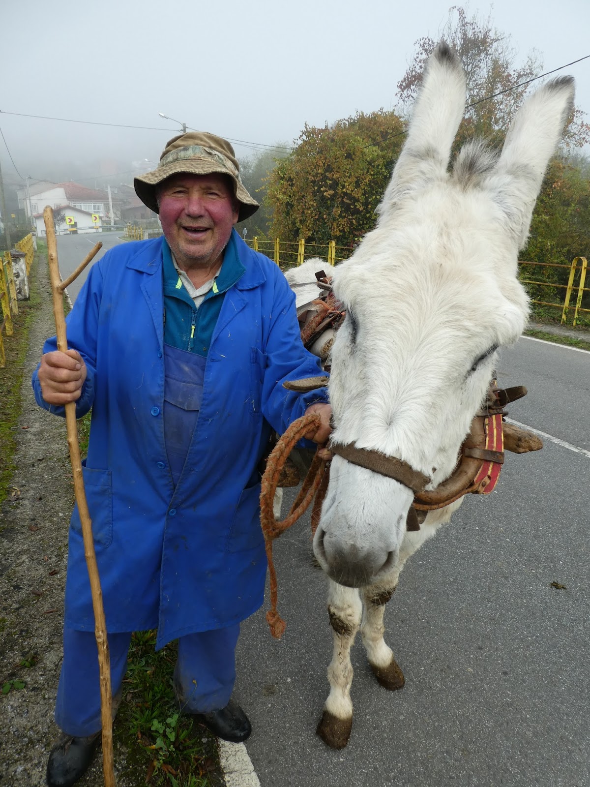
I met this handsome pair at A Vide, on the way out of Monforte de Lemos.

Chantada, and one soportalis (right)

Chantada (above, and below)

Getting to Chantada was hard work, as I had a couple of big ascents and descents. I had left the River Sil, and this was the day I crossed the Rio Miño, but have now left that far behind too. Approaching the Rio Miño I had to follow a very steep path downhill. It was very rocky, and the way the rocks were arranged so carefully made me think that I was probably walking on an ancient road. Parts of the path hadn't seen the sun all day and so the rocks glistened with moisture, reminding me to take care. The path was so steep that it zig-zagged it's way down the hill, and once over the bridge, the road I chose to follow (less steep) zig-zagged up the hill! Despite the incredible steepness, every available piece of arable land was in use, primarily with vines, but some vegie patches too. The vineyards are terraced, and as I plodded up the hill in the late afternoon, wherever I looked, I could see people out, tending the vines.

Diomondi, at the start of the descent down to the Rio Miño, has a beautiful Romanesque Church, an historical monument.

These bovines watch over one door of the Diomondi church

In Diomondi there were two beautiful horreos.

Just one carpet of chestnuts that I am often having to negotiate.

The only way to access the vines is up steps such as these.

Terraced vineyards, and the last of the zig-zag (downhill) path can be seen cutting diagonally across and down.

Looking down on Belesar, on the Rio Miño. Note the terraced vineyards behind.

A horreo (used for storing grain) in Penasillás, on the way to Alto de Faro - a five kilometre climb is about to start!

Tackling the last bit of the climb up Alto de Faro.

Ermita de Nosa Señora do Monte do Faro.

The cruceiro with the Ermita in the background.
When it came time to push on I had my first real "don't know" moment on this journey. I couldn't find any yellow arrows, only a mojón pointing down the hill. I went that way briefly, it felt wrong and so I climbed back up to check I hadn't missed anything. Still no joy, and so climbed the few metres to the top of the Alto, and again, no joy! I consulted Google maps and decided that I would forgo the Camino and make my own way to Rodeiro where I planned to spend the night. The route it took me was on tiny little tracks, and with no uphills to speak of. At one point, in the distance I could hear a dog/s barking, and was a little fearful. As I approached the small hamlet, the dogs let loose, and were loose, but fortunately their masters were sitting on a wall having a late afternoon natter. I stood still and waited for things to calm down, had a chat to the two men and a woman, and headed off to Rodeiro, reaching my destination about a half hour later.

Looking down from the Alto to the Ermita, where I had my peaceful lunch break.

The path that Google maps took me down - very steep, and very rocky. It was slow work until I got to the bottom!
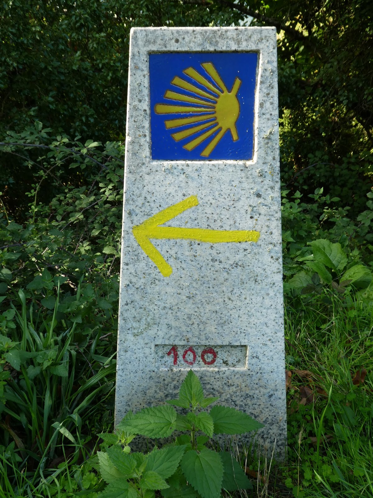
I am now well past this marker (at the start of the descent at Diomondi), but it is nice to see one not spoilt with graffiti!


Beautiful, beautiful region- what a wonderful selection of photos Janet. Love the landscapes and the buildings. Glad you didn't get too 'lost' when the path wasn't obvious...
ReplyDelete